Vintage globe of the world for sale in an antique shop showing the Indian Ocean and surrounding countries including India, the eastern coast of...
globo do mundo para a austrália e a nova zelândia - map of the new world - fotografias e filmes do acervo
Prime Minister of the State of Israel Benjamin Netanyahu holds up a map as he speaks during the United Nations General Assembly at the United Nations...
The Vinland Map, possibly the first map showing the New World, a 15th cenury 'mappa mundi' that some consider to be a fake. Ink on vellum.
The Partition of Europe under Treaties of Paris, June 1919', . 'Independent States coloured separately; Names of New States shown in Red capitals;...
Map illustrating the Brest-Litovsk Treaties', First World War, circa 1918, . Pink: 'Areas taken by Germany'; dark blue: 'Nationalities of...
ilustrações, clipart, desenhos animados e ícones de mapa azul da américa do norte com bandeira contra fundo branco - map of the new world
Ge_graphik_ Hyph_g_sis, lit. 'Geographical Guidance'), also known by its Latin names as the Geographia and the Cosmographia, is a gazeteer, an atlas,...
Map of the United States, 1902. With insets of New York and San Francisco. From The Century Atlas of the World. [John Walker & Co, Ltd., London,...
ilustrações, clipart, desenhos animados e ícones de mapa da américa do norte com bandeiras contra fundo branco - map of the new world
ilustrações, clipart, desenhos animados e ícones de mapa de demarcação espanhola do novo mundo - map of the new world
Hydrographic Map of Brazil. From the illuminated manuscript Portuguese nautical Atlas by Loppo Homem , 1519. Bibliotheque Nationale de France, Paris "
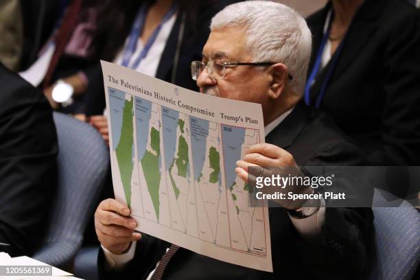
Palestinian President Mahmoud Abbas holds up a Vision for Peace map while speaking at the United Nations Security Council on February 11, 2020 in New...
ilustrações, clipart, desenhos animados e ícones de ano novo símbolo vintage em fundo desfocado mundo vibrante - map of the new world
aluno com máscara facial espera na sala de aula. processo de educação em pandemia. - map of the new world - fotografias e filmes do acervo
Prime Minister of the State of Israel Benjamin Netanyahu holds up a map as he speaks during the United Nations General Assembly at the United Nations...
The World at the Beginning of the 20th Century Showing British Possessions' [in pink], circa 1900. From "Cassell's History of England, Vol. IX"....
An 1826 Mercator projection map of the World shows all the continents and oceans. It includes such entries as New Holland, United Provinces, Southern...
Jacques Cartier, , French sailor and explorer who laid claim to the St. Lawrence River area for France. The illustration depicts him with a globe, in...
Map XV, The World Showing the Colonial Possessions, by A. Von Steinwehr, from Thalheimer's Medieval and Modern History, by Permission, Color...
Gerardus Mercator, a Flemish German was a cartographer renowned for creating a world map based on a new projection which represented sailing courses...
estudante pintando o mapa do mundo do globo para uma nova ideia de vida bonita, limpa, mais viva e feliz. - map of the new world - fotografias e filmes do acervo
Map of Oceania, 1902. Showing Australia and New Zealand, and the East Indies Archipelago. From The Century Atlas of the World. [John Walker & Co,...
Persian Empire Map, Illustration, Ridpath's History of the World, Volume I, by John Clark Ridpath, LL. D., Merrill & Baker Publishers, New York, 1894.
Richard Hakluyt, the Principal Navigations, London reprinted 1889. World map. Australia was yet to be 'discovered'. 'By the discoveries of Sir...
Nautical map of Hispaniola , the most populous island in the Americas, and Puerto Rico . The name originally given by Christopher Columbus, who...
View of the African and European continents on Google Earth, on a computer screen in Paris 06 August 2005. The world at your fingertip, with the...
Map of North America, Illustrating the American War of Independence', circa 1785, . The American Revolutionary War or American War of Independence...
Map of the East Indian Archipelago, 1902. Showing Java, Sumatra, Borneo, Siam, The Philippines, Papua New Guinea and the South China Sea. From The...
Engraving by Tardieu. Abel Tasman was the first European to visit New Zealand in 1642. Illustration from �Voyage pittoresque autour du monde� by...
Considered the most important 16th century map of Florida and Cuba. Titled "Floridae Americae Provinciae Recens & Exactissima Descriptio Auctore...
ilustrações, clipart, desenhos animados e ícones de new zealand radar mapa-múndi vetorizadas royalty free - map of the new world
ilustrações, clipart, desenhos animados e ícones de velho, mapa da europa oriental e ocidental, hemispheres, desde 1875 - map of the new world
Orontius Finaeus reprinted 1889. Top: 'Terra Australis' on the left. Europe, Russia, the North Pole, China and northern Africa on the right. Bottom:...
European-Revue-Kill-That-Eagle-1914. Cartoon map of Europe at the beginning of World War I. The map is showing Austria-Hungary at the centre,...
Protestors hold a Ukrainian flag depicting a map of the country during a demonstration in support of Ukraine, in Madrid, on February 24 on the first...
Map entitled 'Taurica Chersonesus' , 1645. It originally appeared in 'Theatrum Orbis Terrarum, sive Atlas Novus in quo Tabulae et Descriptiones...
Map of the World - Dieu et Mon Droit, Map of the World, AD 1600. The 'new map' in Shakespear[e]'s 'Twelfth Night'. With text by C.H. Coote . Scale...
Secretary General Jens Stoltenberg poses in front of a map of the world in his office on the first day's work in the new Nato headquarters' building...
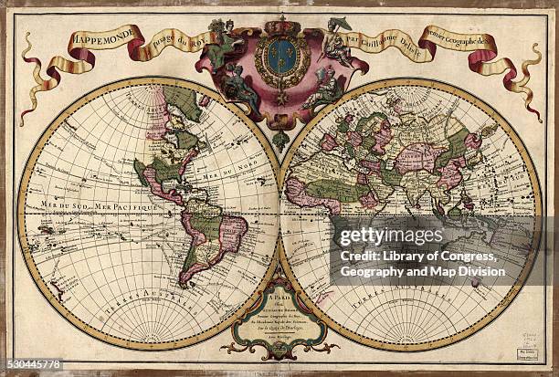
Bowles's new and accurate map of the world, or Terrestrial globe : laid down from the best observations and newest discoveries particularly those...
The island of Hispaniola, with the two spanish colonies Spagnola and Isabella, founded by Columbus in the first and in the second voyage to the New...
Somewhat inaccurate map of Florida and North America by Theodor de Bry for a series on great voyages, from the manuscripts of a French Huguenot, Le...
Map of the world on the Mercator projection, exhibiting the American continent as its center, 1900. From the New York Public Library. .
Set of Countess Mountbattens underwear made from a silk map given to her by a boyfriend in the Royal Air Force is displayed at the 'Fashion on the...
Map of New York City, USA, c1930s. A print from Countries of the World, edited by JA Hammerton, volume V, the Fleetway House, London, c1930s.
Participant of the No Pants Subway Ride looks at a subway map while riding a train on January 12, 2014 in Berlin, Germany. The annual event, in which...
World map indicating Greenpeace ship locations hangs on the wall of the Rainbow Warrior whilst docked at the Overseas Passenger Terminal in Circular...
Apple Senior VP of iPhone Software Scott Forstall demonstrates the new map application featured on iOS 6 during the keynote address during the 2012...
Founder and CEO of iMediSync Inc. Dr. Seung Wan Kang displays the new consumer version of iMedisync's iSyncWave for digital brain health monitoring...
Nicolaes Visscher I was a Dutch cartographer, engraver and publisher, the son of famed Dutch Golden Age draughtsman Claes Janszoon Visscher. He...


![The World at the Beginning of the 20th Century Showing British Possessions' [in pink], circa 1900. From "Cassell's History of England, Vol. IX"....](https://media.gettyimages.com/id/1511734190/pt/foto/the-world-at-the-beginning-of-the-20th-century-showing-british-possessions-in-pink-circa.jpg?s=612x612&w=gi&k=20&c=KRJp9YQ_nY5IdL8pPs6BkacA9wRqffMUZCiV3XXsmCc=)


![Map of the World - Dieu et Mon Droit, Map of the World, AD 1600. The 'new map' in Shakespear[e]'s 'Twelfth Night'. With text by C.H. Coote . Scale...](https://media.gettyimages.com/id/1014130724/pt/foto/map-of-the-world-dieu-et-mon-droit-map-of-the-world-ad-1600-the-new-map-in-shakespeares.jpg?s=612x612&w=gi&k=20&c=LHoRlfUvAgP65yVB4xrAaQeFtieUjEUrAzufImBqX2I=)


